
Cherry Creek Minor Tributaries
Background
Dewberry is contracted to complete a Major Drainageway Planning (MDP) study and Flood Hazard Area Delineation (FHAD) study for the previously unstudied tributaries to Cherry Creek. Mile High Flood District (MHFD) engaged Dewberry to conduct this study, which incorporates the following sponsors: City of Aurora, Arapahoe County, and Southeast Metro Stormwater Authority (SEMSWA). The project is studying eleven (11) tributary basins, including Little Raven Creek (previously North Unnamed), Suhaka Creek, Joplin Tributary, Grove Ranch Tributary, Valley Club Acres Tributary, North Arapahoe Tributary, South Arapahoe Tributary, Chenango Tributary, Kragelund Tributary (previously South Unnamed), and 17 Mile Tributary.
The purpose of this study is to analyze the existing and future floodplain delineation, assess stream functionality, and develop a set of alternatives and plans that will maintain the ecological health of the reach and address existing and future flooding and erosion concerns. The drainage basin is almost fully developed except for Cherry Creek State Park and the proposed King’s Point development northeast of E-470 and Parker Rd. Except for Cherry Creek State Park, existing land uses largely consist of residential and commercial areas.
The four phases of the MDP study are to 1) assess baseline hydrology, 2) create a FHAD, 3) conduct an alternatives analysis, and 4) formulate a conceptual design. Project goals include:
- Update hydrology in the basin,
- Identify existing flooding and drainage issues,
- Obtain and consider input from the public, stakeholders, and sponsors for feasible alternatives,
- Recommend conceptual stormwater conveyance, high functioning and low maintenance stream corridors, and detention improvement measures.
Project Area Map

Interactive Map
Click here to view the full interactive map in a new window
Tributaries
Overview
Little Raven Creek, previously referred to as North Unnamed Tributary, coveys runoff from an approximately 349-acre basin and is 7,700 feet in length. This tributary basin includes about 93 acres in the City of Greenwood Village and 256 acres in unincorporated Arapahoe County, 133 acres of which is served by SEMSWA. The area not served by SEMSWA is owned by Cherry Creek State Park. The area is fully built out and there are no vacant properties for future development within the basin.

FHAD
Little Raven Creek is included in the FHAD. Due to the build-out nature of this basin, future land use hydrology was used for the FHAD and is considered equal to existing for Little Raven Creek. There are three residential homes identified as being in the upper portion of the Little Raven Creek 100-year floodplain. The upstream portion of the channel also appears to have erosional issues and there are no water quality features on Little Raven Creek. The alternatives analyzed for this tributary are as follows.
Recommended Alternative
The improved channel will increase public safety by removing three insurable structures from the floodplain. Additionally, the recommended high function low maintenance process channel will increase the environmental function of the reach by providing a more natural stream environment and reconnecting the channel to its natural plan and form. Furthermore, a recreational/maintenance trail along the channel corridor and replacement of park programming in the overbank region will benefit the surrounding community.The water quality pond recommended by the CCBWQA will improve the water quality of flow conveyed downstream into Cherry Creek.
Overview
Suhaka Creek, previously referred to as Tributary to Cottonwood Creek, conveys runoff from approximately 360 acres of single-family development with open space at the downstream reaches. Most of the watershed lies in unincorporated Arapahoe County with a small 9-acre area located in Greenwood Village near Lake Ct. Approximately 193 acres of this area is served by SEMSWA and the area not served by SEMSWA is owned by Cherry Creek State Park.
FHAD
Suhaka Creek is not included in the FHAD since there is little to no open channel. Due to the built-out nature of this basin, future land us hydrology is considered equal to existing for Suhaka Creek.
Recommended Alternative
The recommended conveyance improvements include upsizing the existing culvert and Cherry Creek Drive slightly from dual 60” RCPs to dual 66” RCPs. Additionally, structural energy dissipation is required downstream of the improved culverts to mitigate the potential for severe erosion of the roadway and in the channel downstream of the crossing. The improved culvert crossing with energy dissipation will reduce the erosion potential downstream of the culverts, resulting in less sediment conveyed downstream into Cherry Creek.
Overview
Joplin Tributary is a large tributary to Cherry Creek and is approximately 9,700 feet in length. The downstream half of the tributary runs through Cherry Creek State Park where it crosses multiple park trails, and the other half upstream of S. Parker Rd. conveys runoff from dense, mixed-use developments comprised of commercial big box stores and single- and multi-family developments in the Cities of Aurora and Centennial. The Joplin watershed combines a 360-acre area in the City of Aurora, a 217-acre area in the City of Centennial, and a 197-acre area in unincorporated Arapahoe County. SEMSWA serves the City of Centennial area and approximately 59 acres of unincorporated Arapahoe County.

FHAD
Joplin tributary is included in the FHAD. Due to the built-out nature of the basin, future land use hydrology was used for the FHAD and is considered equal to existing for Joplin Tributary. See the final FHAD report under the reports tab.
Recommended Alternative
To address minor erosional issues identified in the Joplin Tributary and the need for water quality within the basin, the Status Quo alternative along with retrofits adding water quality functionality to existing Pond RB1-Pond 4 is recommended. The addition of water quality functionality to existing Pond RB1-Pond 4 and stabilization of minor erosional issues will result in increased water quality discharged downstream into Cherry Creek.
Overview
Grove Ranch Tributary is the smallest watershed studied at 81 acres and less than a mile in basin length. The Grove Ranch watershed is served entirely by SEMSWA, with 77 acres located in the City of Centennial and 4 acres within unincorporated Arapahoe County.
FHAD
Grove Ranch tributary is not included in the FHAD since there is little to no open channel. Due to the built-out nature of this basin, future land use hydrology is considered equal to existing for Grove Ranch Tributary.
Alternatives
No alternatives were evaluated for this basin
Overview
Valley Club Acres Tributary drains a tributary area of approximately 207 acres. The tributary is predominantly contained in storm sewer, with only 600 feet of open channel at the downstream confluence with Cherry Creek. The entire open channel reach is encumbered by the regulatory floodplain of Cherry Creek, as are approximately 1,500 feet of the upstream storm sewer. The Valley Club Acres Tributary area is composed of 110 acres in the City of Centennial, 91 acres in the City of Aurora, and 6 acres in unincorporated Arapahoe County. SEMSWA serves the areas in the City of Centennial and unincorporated Arapahoe County.
FHAD
Valley Club Acres Tributary is not included in the FHAD since there is little to no open channel. Due to the built-out nature of this basin, future land use hydrology is considered equal to existing for Valley Club Acres Tributary.
Recommended Alternative
The recommended conveyance improvements, including upsizing undersized sections of the existing storm sewer trunk line with dual 10’x4’ RCBCs along S. Helena St. and E. Caley Ave. and a 60-inch RCP along S. Lewiston Way, will increase public safety by reducing flooding of roadways within the basin and properties within the Valley Club Acres community. The recommended water quality pond will improve water quality conveyed downstream into Cherry Creek.
It is advised that conveyance capacity improvements recommended in the North Arapahoe Tributary be constructed prior to or in conjunction with stormwater capacity improvements recommended in the Valley Club Acres Tributary. As noted previously, inter basin transfer from North Arapahoe into Valley Club Acres Tributary occurs as a result of undersized drainage infrastructure in the existing condition in the North Arapahoe Tributary. If improvements in the North Arapahoe Tributary basin are not implemented prior to or in conjunction with improvements recommended in the Valley Club Acres Tributary, flooding issues will persist in the Valley Club Acres Tributary as the Valley Club Acres Tributary improvements recommended herein and were not designed to handle additional flow from the North Arapahoe basin transfer.
Overview
The North Arapahoe watershed combines a 372-acre area, 206 acres of which are served by SEMSWA, 115 acres by the Town of Foxfield, and 51 acres by the City of Aurora. This watershed includes 141 acres in unincorporated Arapahoe County. Runoff from North Arapahoe watershed east of S. Buckley Rd. is conveyed in storm sewer and through a SEMSWA owned and maintained regional detention pond. Further downstream, runoff is conveyed under S. Parker Rd. before discharging directly to Cherry Creek. The uppermost part of this watershed is located south of E. Arapahoe Rd. in the Town of Foxfield.
FHAD
North Arapahoe Tributary is not included in the FHAD since there is little to no open channel. Due to the built-out nature of this basin, future land use hydrology is considered equal to existing for North Arapahoe Tributary.
Recommended Alternative
The recommended storm sewer improvements, including upsizing undersized sections of the existing storm sewer trunk line within E. Arapahoe Rd. with 36” to 72” RCP will increase public safety by reducing flooding of Arapahoe Road and basin transfer into the Valley Club Acres Tributary by conveying runoff within the storm sewer trunkline in Arapahoe Rd. The recommended water quality pond will improve water quality conveyed downstream into Cherry Creek for the CCBWQA.
It is advised that conveyance capacity improvements recommended in the North Arapahoe Tributary be constructed prior to or in conjunction with stormwater capacity improvements recommended in the Valley Club Acres Tributary.
Overview
The South Arapahoe watershed combines a 317-acre area in the Town of Foxfield, a 70-acre area in the City of Aurora, a 5-acre area in unincorporated Arapahoe County, and a 4-acre area in the City of Centennial. SEMSWA provides service to the City of Centennial area and 3 acres of unincorporated Arapahoe County. A small area of 1.5 acres is located in unincorporated Arapahoe County but is not currently served by SEMWA.
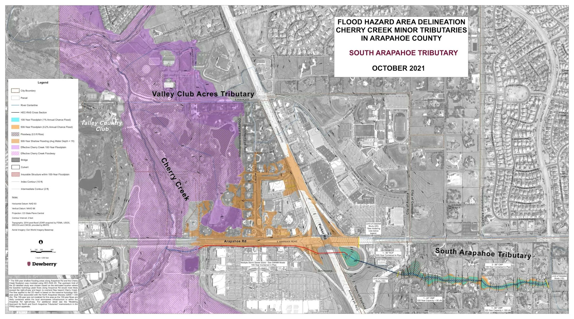
FHAD
South Arapahoe Tributary is included in the FHAD. Due to the built-out nature of this basin, future land use hydrology is considered equal to existing for South Arapahoe Tributary.
Recommended Alternative
The recommended conveyance improvements include upsizing the existing culvert at S. Norfolk Ct. from a 48” CMP to dual 48” RCPs, and at S. Pitkin St. from a 60” CMP to dual 60” RCPs. Additionally, energy dissipation structures are recommended downstream of both culvert crossings to reduce outlet hydraulics to those permissible in the receiving channel.
The improved culvert crossings will reduce public safety concerns by providing an unobstructed emergency access route for areas of the community that were previously cut off during the 100-year event (see FHAD). Additionally, the improved culvert crossings with energy dissipation will reduce the erosion potential downstream of the culverts, and therefore improve water quality conveyed downstream into Cherry Creek.
Overview
Chenango Tributary is the largest watershed and conveys runoff from 920 acres to Cherry Creek through the Cherry Creek Valley Ecological Park from the Chenango Development, which is a single-family large lot rural development that is fully built out. The Chenango watershed combines a 450-acre area in the City of Centennial, a 376-acre area in the Town of Foxfield, and a 90-acre area in unincorporated Arapahoe County. SEMSWA serves the areas in the City of Centennial and unincorporated Arapahoe County.

FHAD
Chenango Tributary is included in the FHAD. Due to the built-out nature of this basin, future land use hydrology is considered equal to existing for Chenango Tributary. The flood hazard area delineation (FHAD) identified four insurable structures inundated by the upper portion of the Chenango Tributary 100-year floodplain. The FHAD also identified inundation of approximately 2,850 LF of E. Hinsdale Way and 170 LF of S. Yampa St. during the 100-year event, which poses a public safety concern. Both the insurable structures and roadway inundation is caused by inadequate open channel and culvert capacity throughout the reach. Additionally, there are no water quality features on Chenango Tributary. The alternatives analyze for this tributary are as follows.
Recommended Alternative
The improved channel in culverts will increase public safety by removing 4 insurable structures, as well as approximately 2,850 LF of E. Hinsdale Way and 170 LF of S. Yampa St. (Local roadways) from the 100-year floodplain. Additionally, the improved culvert crossings will reduce public safety concerns by providing an unobstructed emergency access route for homes within the community that were previously cut off during the 100-year event (see FHAD). The recommended water quality pond will improve the water quality of the flow conveyed downstream into Cherry Creek for the CCBWQA. Additionally, the recommended high functioning low maintenance process channel will increase the environmental function of the reach by providing a more natural stream environment and reconnecting the channel to its natural plan inform.
Overview
The Tagawa watershed is entirely contained in the City of Centennial, which is served by SEMSWA. The tributary outfalls directly to Cherry Creek and is located to the south of Chenango Tributary and north of Kragelund Tributary.
FHAD
Tagawa Tributary is not included in the FHAD since there is little to no open channel. Due to the built-out nature of this basin, future land use hydrology is considered equal to existing for Tagawa Tributary.
Recommended Alternative
To address minor erosional issues identified in the Tagawa Tributary, the Status Quo alternative is recommended. The Status Quo alternative was evaluated to determine the cost associated with addressing minor erosional issues in the tributary and ongoing maintenance of the study reach. By addressing erosional issues within the tributary, the amount of sediment transported downstream into Cherry Creek will be reduced, increasing water quality.
Overview
Kragelund Tributary conveys runoff from approximately 611 acres of mostly undeveloped land and provides the best opportunity for floodplain preservation and was previously referred to as South Unnamed Tributary. Future development is anticipated from the headwaters near E-470 and King’s Point, through privately owned property currently managed by the Vermillion Creek Metropolitan District, to the confluence with Cherry Creek within the PJCOS. The Kragelund watershed combines a 343-acre area in the City of Aurora, a 259 acre-area in the City of Centennial, and 7-acre area in unincorporated Arapahoe County. SEMSWA serves the areas in the City of Centennial and unincorporated Arapahoe County.

FHAD
Kragelund Tributary is included in the FHAD. Kragelund Tributary is largely undeveloped at the time of this study and therefore existing conditions land use and hydrology were used. Upstream development will be required to discharge at historic rates once developed.
The FHAD identified 10 insurable structures (nine residential and one commercial) in the Kragelund Tributary 100-year floodplain. The FHAD also identified that approximately 630 LF of E. Mineral Pl. (a local roadway) is inundated during the 100-year event which poses a public safety concern. Both the insurable structures and roadway inundation is caused by inadequate open channel capacity throughout the reach. Additionally, upstream development is anticipated to increase the frequency of events in the reach and effect the hydraulic regime of the reach, creating instability in the system. The alternatives analyze for this tributary are as follows.
Recommended Alternative
Recommended conveyance improvements include a high functioning low maintenance process channel, in combination with 9 three-foot grade control structures, one maintenance access trail and two trail culvert crossing improvements within open space areas designed to convey the 100-year event.
The conveyance capacity improvements will increase public safety by removing ten insurable structures, as well as approximately 630 LF of E. Mineral Pl. from the 100-year floodplain. The recommended high functioning low maintenance process channel will reduce the potential for upstream development-induced erosion within the reach, improving water quality conveyed downstream into Cherry Creek. Additionally, the recommended high functioning low maintenance process channel will increase the environmental function of the reach by providing a more natural stream environment and reconnecting the channel to its natural plan and form.
Overview
17 Mile watershed combines a 97-acre area in the City of Aurora, a 16 acre-area in the City of Centennial, and 15-acre area in unincorporated Arapahoe County. SEMSWA serves the areas in the City of Centennial and unincorporated Arapahoe County. It is the most southern tributary of this study and is located just north of the Arapahoe County / Douglas County border. This poorly defined tributary drains approximately 145 acres, and is bisected by S. Parker Rd. This watershed is also largely undeveloped upstream of S. Parker Rd. but is expected to be fully built-out following development of King’s Point.
FHAD
17 Mile Tributary is not included in the FHAD since there is little to no open channel. 17 Mile Tributary is largely undeveloped at the time of this study and therefore existing conditions land use and hydrology were used. Upstream development will be required to discharge at historic rates once developed.
Recommended Alternative
The recommended conveyance improvements include a high functioning low maintenance process channel, in combination with 8 two-foot grade control structures, and one access road culvert crossing designed to convey the 100-year event.
The conveyance capacity improvements will increase public safety by reducing the 100-year floodplain inundation area within a historical parcel and will benefit the community by containing the 100-year floodplain with a reduced footprint. The recommended high functioning low maintenance process channel will reduce the potential for upstream development-induced erosion within the reach, improving water quality conveyed downstream into Cherry Creek. Additionally, the recommended high functioning low maintenance process channel will increase the environmental function of the reach by providing a more natural stream environment and reconnecting the channel to its natural plan and form. Coordination with the conservation easement grantees is anticipated to in the future to obtain permits from the work.
Contact
Brooke Seymour, bseymour@mhfd.org
Jim Watt, jwatt@mhfd.org